Storm graphics show two systems still on track for Caribbean area Loop Cayman Islands
Black Immigrant Daily News
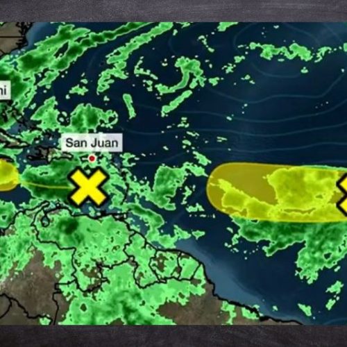
According to the National Hurricane Center, as of Saturday, August 27, 2022, two bad weather systems were in or near the Caribbean region. These are described below.
Eastern Caribbean Sea
Over the Eastern Caribbean Sea, the NHC reported a trough of low pressure, producing minimal shower and thunderstorm activity.
Environmental conditions could become more conducive for slow development of this system during the early or middle part of next week while it moves generally westward at 10 to 15 mph across the central and northwestern Caribbean Sea.
The chance of formation through the next five days is low, at 20 per cent.
Central Tropical Atlantic
Over the central tropical Atlantic Ocean, the NHC reported a broad and complex area of low pressure, which is producing disorganized showers and thunderstorms.
The interaction of this feature with an approaching tropical wave could support some gradual development of the system during the early and middle parts of next week while it moves westward to west-northwestward at about 10 mph across the central tropical Atlantic.
The chance of formation through the next five days is low, at 30 per cent.
Dry air helping to calm storm development
In addition to the NHC reports, The Weather Channel reported that dry air is present “over parts of the Caribbean Sea and Atlantic Ocean near and east of the Lesser Antilles,” which “is likely to keep a lid on Caribbean Sea development for the next few days.” An image of the areas of dry air are depicted below.
Areas of dry air
NewsAmericasNow.com


Leave a Reply
Want to join the discussion?Feel free to contribute!