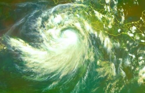
UPDATE Sep 5: Kay now a hurricane, threatens Mexico and California Loop Cayman Islands
Black Immigrant Daily News
As an update to the below advisory, Tropical Storm Kay is now a category 1 hurricane, with maximum sustained winds of 80 mph and moving west-north-west in range of 10 to 12 mph.
Hurricane Kay is expected to continue this movement into Monday night and then flow in a northwest to north-northwest motion by late Tuesday.
Based on the forecast track, the National Hurricane Center said that the center of Hurricane Kay is expected to remain south and southwest of southwestern Mexico through tonight, then move to the west of the southern Baja California peninsula on Wednesday.
In terms of impacts, Hurricane Kay may produce 3 to 6 inches of rainfall, with isolated storm total amounts of 10 inches, across portions of the Mexican Riviera and western Mexico through Wednesday night. These rainfall amounts could lead to flash flooding, including landslides.
Swells may also affect portions of the coast of southwestern Mexico during the next few days.
Large swells are likely to reach the southern portion of the Baja California peninsula on Tuesday and are expected to spread up the peninsula and the Gulf of California later this week.
These swells will likely cause life-threatening surf and rip current conditions.
As a result of the foregoing, a tropical storm watch is in effect for Loreto southward to Cabo San Lucas and Cabo San Lucas northward to Puerto San Andresito.
Residents in Baja Califorinia must also pay attention to this development as similar warnings may be issued for Baja Califorinia on Monday night or Tuesday.
INITIAL ADVISORY:
Tropical Storm Kay may become a hurricane soon
Early Monday morning, September 5, 2022, Tropical Storm Kay was displaying maximum sustained winds near 45 mph with higher gusts, south of Mexico and California.
If Tropical Storm Kay continues to strengthen, the system may become a category 1 or 2 hurricane later this week.
According to the National Hurricane Center, swells and gusty winds generated by Kay will affect portions of the coast of southwestern Mexico during the next several days, and are likely to cause life- threatening surf and rip current conditions. These swells are expected to reach the southern portion of the Baja California peninsula by Tuesday.
In addition, these areas can expect several inches of rainfall over the next few days, as displayed in the chart below.
Tropical Storm Kay rainfall predictions from The Weather Channel
As a consequence, residents on the southwestern Mexico coast and the Baja California peninsula should remain vigilant and monitor Tropical Storm Kay as the system develops.
NewsAmericasNow.com


Leave a Reply
Want to join the discussion?Feel free to contribute!