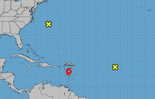
Tropical Storm Fiona is very close to the Leeward Islands
Black Immigrant Daily News
At 500 PM AST (2100 UTC), the center of Tropical Storm Fiona was located near latitude 16.4 North, longitude 61.1 West.
Fiona is moving toward the west near 15 mph (24 km/h). A westward to west-northwestward motion with a decrease in forward speed is expected through early Monday. A turn toward the northwest is forecast later on Monday.
On the forecast track, the center of Fiona is expected to move across the Leeward Islands during the next few hours, near or just south of the Virgin Islands and Puerto Rico Saturday into Sunday, and approach the southern or eastern coast of the Dominican Republic Sunday afternoon.
Fiona is forecast to move across the Dominican Republic Sunday night and Monday.
Maximum sustained winds are near 50 mph (85 km/h) with higher gusts.
Gradual strengthening is forecast during the next 48 hours or so before the center of Fiona reaches the Dominican Republic on Sunday.
Tropical-storm-force winds extend outward up to 140 miles (220 km) from the center.
Observations from Guadeloupe indicate that the minimum central pressure is 1004 mb (29.65 inches).
HAZARDS AFFECTING LAND
———————-
Key messages for Tropical Storm Fiona can be found in the Tropical Cyclone Discussion under AWIPS header MIATCDAT2 and WMO header WTNT42 KNHC and on the web at hurricanes.gov/text/MIATCDAT2.shtml.
WIND: Tropical storm conditions are beginning across portions of the Leeward Islands within the warning area and will continue through Saturday.
Tropical storm conditions will spread westward to the U.S. and British Virgin Islands Saturday morning, and across
Puerto Rico Saturday afternoon and Saturday night. Tropical storm conditions are possible on Dominica this evening or tonight and cross the watch area in the Dominican Republic beginning Sunday afternoon.
RAINFALL: Fiona is forecast to produce the following rainfall totals:
Leeward Islands and Northern Windward Islands: 3 to 6 inches.
British and U.S. Virgin Islands: 4 to 6 inches
Puerto Rico: 4 to 8 inches with maximum totals of 12 inches,
particularly across eastern and southern Puerto Rico.
Dominican Republic: 6 to 10 inches with maximum totals of 16 inches
possible
Haiti: 1 to 3 inches with isolated maximum totals of 5 inches
Turks and Caicos: 4 to 8 inches
These rains may produce flash and urban flooding, along with mudslides in areas of higher terrain, particularly southern and eastern Puerto Rico and the eastern Dominican Republic.
STORM SURGE: The combination of storm surge and the tide will cause normally dry areas near the coast to be flooded by rising waters moving inland from the shoreline. The water could reach the following heights above ground somewhere in the indicated areas in areas of onshore winds if the peak surge occurs at the time of
high tide…
Southern coast of Puerto Rico…1 to 2 ft Localized coastal flooding is also possible elsewhere in Puerto
Rico and the U.S. Virgin Islands. For information specific to your
area, please see products issued by your local National Weather
Service forecast office. Storm surge will raise water levels by as much as 1 to 3 feet above normal tide levels along the immediate coast in areas of onshore winds in the Dominican Republic.
SURF: Swells generated by Fiona are affecting the Leeward and
northern Windward Islands, and are beginning to reach the Virgin
Islands and Puerto Rico. Swells will then reach the northern coast
of Hispaniola, the Turks and Caicos Islands, and the southeastern
Bahamas over the weekend. These conditions could cause
life-threatening surf and rip current conditions. Please consult
products from your local weather office.
CLICK HERE TO JOIN OUR WHATSAPP GROUP
NewsAmericasNow.com


Leave a Reply
Want to join the discussion?Feel free to contribute!