Tropical wave update:Montitoring large area of disorganised convection Loop Barbados
Black Immigrant Daily News
Update: Tuesday,September 20, 2022 at 11:58 AM
The Barbados Meteorological Services continues to closely monitor the progress of a Tropical wave located near 54W south of 14N at 12 noon today.
Current Situation:
Over the past 12 hours, satellite imagery continued to show a large area of disorganised convection associated with the system tracking westward at around 10 to 15 knots (20 to 30 km/h).
Intensity and track Forecast:
Current model guidance is in agreement with a track south of Barbados during the day on Wednesday.
Rapid intensification of the system is unlikely as it approaches Barbados and the southern Windward islands. However, further analysis suggests some slow development as the system moves into the Caribbean Sea by the end of the week.
With Barbados on the northern fringe of the activity, there is the possibility of one to three inches of rainfall as the wave affects the island from Wednesday. Winds are likely to be between 20 to 25 knots (35 to 45 km/h) with higher gusts possible during heavy shower activity. An additional one to two inches of rainfall are possible as activity trailing the wave persists across the island into Thursday, September 22, 2022.
The next update will be at 6 pm today, Tuesday, September 20, 2022.
[Orginal story: September 19, at 6pm]
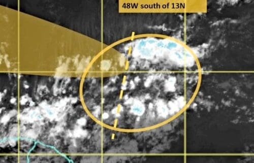
The Barbados Meteorological Services is closely monitoring the progress of a tropical wave located near 48W south of 13N as of 11 am today (September 19, 2022).
According to the statement issued, convection associated with the tropical wave is disorganized at this time as it moves slowly westward at 10 to 15 knots.
Current model guidance suggests that any development will be slow to occur over the next few days. However, regardless of development, the tropical wave is expected to affect the island sometime between Wednesday and Thursday this week.
During its passage, there is the possibility of two to four inches of rainfall and a deterioration in sea conditions which may warrant the issuance of watches/warnings from tomorrow, Tuesday, September 20, 2022.
The next update will be in 24 hours, around 12 noon tomorrow or sooner if conditions warrant.
NewsAmericasNow.com


Leave a Reply
Want to join the discussion?Feel free to contribute!